The Road to Net Zero
In the race to reach Net Zero, every advantage counts. The clock is ticking and our commitment to developing and building the highest quality renewable energy assets demands both expertise and speed.
But this is not a straightforward pursuit. Solar farms cannot be built anywhere, and the pool of potential sites is limited. The UK is already heavily developed (be it for housing, industrial areas or energy generation), with a wealth of protected natural areas restricting the land available for new projects. In terms of solar, suitable land must also have favourable topography, grid availability, and meet strict environmental and social criteria to obtain planning permission. To top it all off, it must also be large enough to be financially viable.
In this race, our Geographical Information System (GIS) is our guiding light, helping to steer us towards better-positioned and better-connected solar parks. Our investment in GIS enables us to identify the best sites for solar and battery development while ensuring our impact on the environment, community, and grid remains positive. More than just a tool that helps us optimise our builds, it also helps us build sustainably and with integrity.
After such a bold statement, you might wonder how exactly geographical software can help people build better solar farms. But before we answer that, let’s take a step back and answer two key questions: what exactly is a GIS and why is it so important?
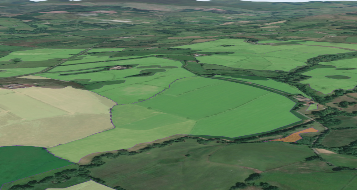
Not all land is suitable to house a solar park, let alone optimal.
We put a substantial investment into making sure each of our solar parks is not only as efficient as possible but also allows for the greatest positive environmental impact. With over 30 million distinct parcels of land in the UK, sifting through them all to find the right place for the right project is no easy task.
A GIS, simply put, enables the sorting, simplification and processing of geographical data. When properly used, a GIS can help renewable companies identify the optimal sites for development based on criteria such as size, location, topography, and more. Being able to sort through gigabytes of data in dozens of formats means we find better sites faster.
Once we find a site that fulfils the required development criteria, we contact the landowner to gauge interest. Only then do we conduct physical site visits to confirm the site’s viability. Using the GIS this way allows us to focus solely on the premium sites while also reducing our impact on the environment.
In the modern era, data is everything. However, there is often far too much data to analyse without a system to help sort through it. Our GIS cuts through the noise to highlight the best opportunities based on nuanced and up-to-date criteria. We aren’t just looking for viable locations, we want the best locations, for the client, community, and environment.
Peter Douglass, Ethical Power’s GID Manager, has spent years developing and perfecting a series of complex models that collate and filter data developing a system tailored to renewable energy development needs. Each successive algorithm analyses UK land availability, and further refines the search, based on criteria such as:
- Topography
- Direct normal irradiation
- Local grid connections
- Conservation designation
- Optimal cable route
- Project constraints
We also draw from areas like grid intelligence and planning prospects to further direct where we engage with landowners. Our grid experts can use one of our apps to create a batch of prospects for engagement. From this batch, individual sites are analysed in greater detail before we approach the landowner with a comprehensive proposal.
GIS even facilitates site visits and enables our field staff to focus on certain features while also utilising the Arc Fieldmaps app for image and data capture.
Ultimately, these modifications have enabled us to find the right land more quickly and improve the likelihood of successful development. The highly refined process of data analysis in our customised GIS eliminates any sites with qualities that could jeopardise the development process.
Understanding Landowners
Being given the time and trust to craft bespoke software solutions has given our team a huge boost, but this is only half of the story. Once we identify the perfect parcel of land, the next step is to contact the landowner and negotiate a lease. For Ethical Power, building and maintaining long-term relationships built on trust and mutual respect is paramount.
Many of the landowners we work with are farmers, and their time is a precious commodity. Crops are heavily threatened by climate change, and the financial margins for many are getting thinner and thinner. For some, the only way to ensure they can pass on their farm to the next generation is to sell parts of it for housing development.
Leasing land to a solar farm offers a viable option for using land which is not suitable for crops while retaining ownership of it. Having an additional reliable income stream can help support the rest of the business and maximise overall land use. The use of agrivoltaics, the dual use of land for both solar and farming simultaneously, is also growing.
Our Land Partnership Manager, PJ Rogers, is a farmer by trade, just like his parents and his grandparents before that. Working on his family farm has given PJ an innate understanding of the realities facing farmers today. He knows first-hand the needs and constraints of landowners, and more importantly, the best ways for us to help them. Thanks to his insight, we can communicate directly with landowners on their own terms and help both parties get the most out of the partnership.
Working with integrity is not just a ‘nice to have’, it is a cultural imperative that runs through each process of our work. We look to build long-term relationships with our landowners, which is only possible with trust and understanding.
Ethical GIS in Action
GIS for site searching, we know it works well and works quickly, but can it be used to the same effect for other purposes? In short, yes!
Recently, the Compliance team approached Peter about the possibility of a planning review and compliance app that could be used from any app or tablet.
Compliance is a crucial part of any renewable asset build, and ensuring every site is fully up to code is a time-consuming endeavour. A single, centralised software solution would lead to massive time and cost savings, as well as safer and more efficient sites.
After two or three iterations, Peter presented the Compliance team with an app that would let a single member of the compliance team capture points of interest and upload georeferenced photos, complete with annotations, to a shared system.
Site teams can then review, action, and update these points of interest all in one location. Peter then led an on-site training session with members of the Compliance team to help them get started with this new geomapping solution.
The team took to the new app like ducks to water, and it will soon be deployed to the wider team. More updates are also planned, such as the inclusion of design and grid data.
What’s Next
As always with Ethical Power, the next step is to continue to grow and improve. We continue to develop our in-house suite of apps, increasing both the number of functions and their ease of access. From Biodiversity Net Gain to Design and Engineering and beyond, the value of custom GIS is endless.
Site searching in 2024 yielded around 3 GW of viable sites, and we are refining our capabilities every day. This isn’t the last you’ll be hearing about our unique development capabilities, so watch this space!